Drone Technology & Uses: Discover How Drones Work and Important Facts
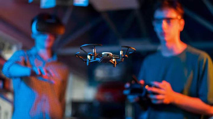
What Is Drone Technology? Drone technology refers to the design and operation of unmanned aircraft that can fly without a person physically sitting inside the aircraft. Drones are also known as unmanned aerial vehicles (UAVs). They can be controlled remotely, follow programmed flight instructions, or combine both approaches.
Modern drones range from small consumer aircraft to larger systems designed for agriculture, mapping, infrastructure inspection, emergency response, research, and other specialized activities. Their size, flight time, sensors, communication systems, and operating capabilities vary according to their intended purpose.
The basic concept of unmanned aircraft has existed for many decades. Advances in lightweight electronics, batteries, satellite navigation, cameras, wireless communication, and automated flight controls have made modern drones more capable and versatile.
How Do Drones Work?
A drone typically combines several systems that work together during flight. Motors and propellers generate thrust, while an electronic flight controller processes information from sensors and adjusts the aircraft's movement.
Common components include:
- Flight controller: Processes sensor information and helps stabilize the aircraft.
- Motors and propellers: Generate the thrust required for flight.
- Battery: Supplies electrical energy to the motors and onboard electronics.
- Navigation system: May use satellite positioning and other sensors to determine location and movement.
- Communication system: Connects the aircraft with a remote controller or other control equipment.
- Camera and sensors: Collect photographs, video, thermal information, or other measurements.
- Obstacle-detection equipment: Helps identify nearby objects on compatible aircraft.
Multirotor drones commonly use several propellers rotating at controlled speeds. By changing the speed of individual motors, the flight controller can control movement, direction, altitude, and rotation.
Autonomous and Remote-Controlled Flight
Some drones are operated continuously by a human pilot through a remote controller. Others can perform specific automated functions, such as following a planned route or maintaining a particular altitude.
Automated flight does not necessarily mean that a drone operates without human oversight. Depending on the aircraft and operating environment, human supervision may remain important for navigation, safety, and compliance with applicable aviation rules.
Importance
Agriculture
Drones can collect aerial information about agricultural fields. Cameras and specialized sensors can help identify variations in crop conditions, vegetation, irrigation patterns, and other characteristics.
Farmers and agricultural researchers can use this information to examine large areas more efficiently than ground inspection alone. Drone-based observations can complement information gathered from field visits, weather data, soil measurements, and satellite imagery.
Mapping and Surveying
Drone technology & uses include aerial mapping and surveying. A drone equipped with a suitable camera can capture many overlapping images of an area, which can then be processed into maps, three-dimensional models, or other geographic information.
Surveying applications can support construction planning, land assessment, environmental observation, and infrastructure documentation. Accuracy depends on the aircraft, camera, positioning technology, flight planning, and processing methods.
Infrastructure Inspection
Drones can capture visual information from structures that may be difficult or hazardous to inspect directly. Bridges, towers, roofs, power infrastructure, industrial facilities, and other structures can be examined from different angles.
Aerial imagery can help identify visible cracks, corrosion, damaged components, or other conditions that require closer examination. Drone inspection does not replace every form of physical inspection because some structural conditions require specialized equipment or direct assessment.
Emergency Response
Drones can support emergency teams by providing aerial information during floods, fires, storms, landslides, and other incidents. Cameras can provide a broader view of affected areas and help teams understand changing conditions.
Some specialized systems can carry equipment or supplies, while others use thermal sensors to identify heat sources or assist with locating people in difficult environments.
Environmental Research
Researchers use drones to observe wildlife, vegetation, coastlines, wetlands, forests, and other environments. Aerial observations can provide information about areas that may be difficult to access on foot.
Drones can also reduce the need for repeated physical travel to certain locations, although their operation must consider wildlife disturbance, environmental conditions, and applicable rules.
| Application | Typical Drone Capability | Example Purpose |
|---|---|---|
| Agriculture | Imaging and sensors | Crop observation |
| Mapping | Aerial photography | 3D models and maps |
| Inspection | High-resolution cameras | Structure assessment |
| Emergency response | Imaging and thermal sensors | Area observation |
| Environment | Imaging and monitoring | Habitat research |
| Photography | Stabilized cameras | Aerial imagery |
Recent Updates
Growth of Drone Applications in India
India has continued expanding its drone ecosystem across agriculture, surveying, infrastructure, logistics, public administration, and other areas. The Ministry of Civil Aviation's Drone Rules, 2021 established a regulatory framework intended to support drone operations while addressing aviation safety and related requirements. (digitalsky.dgca.gov.in)
Government initiatives have also encouraged the use of drones for agricultural activities and land mapping. The SVAMITVA programme, for example, uses drone technology to support the mapping of rural inhabited areas and the creation of property-related records. (svamitva.nic.in)
Drone Use in Agriculture
The agricultural sector has become an important area for drone development. Drone applications can include crop monitoring, field imaging, surveying, and the application of agricultural inputs under applicable rules.
The Ministry of Agriculture and Farmers Welfare has published guidelines concerning the use of drone technology for pesticide application. Such operations involve requirements relating to approved equipment, operational conditions, pilot qualifications, and applicable aviation procedures. (agriwelfare.gov.in)
Drone-Based Mapping
Large-scale mapping continues to be an important drone application. Aerial imagery can be combined with geographic information systems and positioning technologies to create detailed spatial information.
In India, drone surveys have been used under government programmes for village mapping and land-related documentation. These activities illustrate how drone technology can combine aviation, imaging, positioning, and geographic data processing.
Improving Automation
Drone systems increasingly incorporate automated flight planning, obstacle detection, computer vision, and navigation assistance. These technologies can help aircraft maintain routes, stabilize flight, identify objects, and collect data more consistently.
Artificial intelligence can also assist with image analysis. For example, software may classify objects or identify patterns in aerial imagery. The reliability of automated analysis depends on the quality of the collected data, algorithms, environmental conditions, and human review.
Development of Drone Ecosystems
The drone sector is expanding beyond aircraft themselves. Batteries, sensors, communication networks, flight-planning software, mapping applications, data-processing systems, and regulatory platforms all contribute to the broader ecosystem.
This development means that understanding drone technology increasingly involves both aviation concepts and digital technologies such as computer vision, geographic information systems, artificial intelligence, and wireless communication.
Laws or Policies
Drone Rules in India
India's Drone Rules, 2021 provide a major regulatory foundation for civilian drone operations. The framework covers matters such as registration, airspace, operation requirements, and responsibilities associated with drone activities. (egazette.nic.in)
The Directorate General of Civil Aviation (DGCA) oversees civil aviation regulation, including applicable requirements for drone operations. The Digital Sky platform supports regulatory functions related to unmanned aircraft systems. (digitalsky.dgca.gov.in)
Airspace Restrictions
Drone operators need to understand where flights are permitted and where restrictions may apply. India's digital airspace framework uses designated zones to communicate operational requirements.
Before a flight, operators should verify the applicable airspace information and follow current DGCA requirements. Restrictions can be particularly important around airports, sensitive installations, and other designated areas.
Remote Pilot Requirements
Depending on the category and circumstances of a drone operation, pilot training, certification, or other requirements may apply. The applicable rules can vary according to the aircraft and activity.
Operators should use current DGCA guidance rather than relying on older information because aviation regulations and operational procedures can change.
Privacy and Data Considerations
Drones equipped with cameras can collect images of people, buildings, vehicles, and private spaces. Operators should therefore consider privacy and data protection when collecting, storing, processing, or sharing aerial information.
India's Digital Personal Data Protection Act, 2023 establishes a framework for processing digital personal data. The Digital Personal Data Protection Rules, 2025 provide additional implementation details under the Act. (meity.gov.in)
The exact obligations depend on the nature of the data and the circumstances in which it is processed.
Tools and Resources
Digital Sky
Digital Sky is India's digital platform for unmanned aircraft system regulation. It provides information and functions associated with drone operations and regulatory processes.
Operators can use official aviation resources to understand applicable requirements, airspace information, and other regulatory procedures. (digitalsky.dgca.gov.in)
Flight Planning Applications
Flight-planning tools can help operators prepare routes, review terrain, estimate battery requirements, and organize aerial surveys. Professional mapping workflows may also connect flight-planning applications with geographic information systems.
The appropriate tool depends on the drone model, mission requirements, operating environment, and required data quality.
Mapping and Photogrammetry Software
Photogrammetry software can process overlapping aerial photographs into outputs such as orthomosaics, elevation models, point clouds, and three-dimensional models.
These tools are particularly useful for surveying, construction documentation, agriculture, mining, and environmental research.
Weather Information
Weather conditions can significantly affect drone operations. Wind, rain, visibility, temperature, and other environmental factors can influence flight stability, battery performance, and image quality.
Checking reliable weather information before a flight can help operators assess whether conditions are appropriate for the planned activity.
Maintenance and Flight Records
Keeping records of inspections, battery condition, flight activity, software versions, and maintenance can help organize drone operations. Batteries in particular require appropriate storage, charging, handling, and inspection according to the manufacturer's instructions.
Regular equipment checks can also help identify damaged propellers, loose components, sensor problems, or other issues before flight.
FAQs
What is Drone Technology & Uses?
Drone Technology & Uses refers to the technologies that allow unmanned aircraft to fly and the different activities they can support. Applications include agriculture, mapping, inspection, photography, research, and emergency response.
How does drone technology work?
Drone technology combines motors, propellers, batteries, flight controllers, sensors, navigation systems, and communication equipment. The flight controller processes sensor information and adjusts the aircraft's movement to maintain controlled flight.
What are common Drone Technology & Uses?
Common Drone Technology & Uses include aerial photography, land mapping, agricultural observation, infrastructure inspection, environmental research, emergency assessment, and surveying.
Are drones regulated in India?
Yes. Civilian drone operations in India are governed by aviation regulations that include the Drone Rules, 2021 and requirements administered by the DGCA. Specific requirements depend on the drone category and type of operation.
Can drones operate automatically?
Some drones can perform automated functions such as route following, altitude control, return-to-home procedures, obstacle detection, and programmed data collection. The level of automation varies between aircraft, and human oversight may still be required.
Conclusion
Drone technology combines aircraft design, electronics, sensors, navigation, communication, and software to enable controlled unmanned flight. Drone Technology & Uses now extend across agriculture, mapping, infrastructure inspection, emergency response, environmental research, and many other fields. Recent developments are increasing automation, improving data collection, and expanding the range of applications. In India, drone activities operate within an evolving regulatory framework that includes aviation, airspace, pilot, and data-related considerations.