Drone Machine Guide: Explore Key Features, Insights & Helpful Details
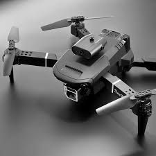
Drone machines, commonly known as unmanned aerial vehicles (UAVs), are remotely controlled or automated flying systems designed for observation, data collection, imaging, transportation, and technical operations. They emerged from early military applications, where aerial surveillance was required without placing pilots at risk. Over the past decade, technological improvements in navigation, sensors, artificial intelligence, and lightweight materials have allowed drones to become more accessible and widely adopted in different industries.
Modern drone technology exists to solve complex tasks that require aerial perspectives, quick data gathering, or precision-based monitoring. Whether used for environmental mapping, disaster assessment, industrial inspection, or creative imaging, drones provide a level of reach and efficiency that ground-based tools cannot achieve.
Importance
Drone machines matter today because they help multiple sectors operate more accurately, safely, and efficiently. Their ability to capture real-time information from difficult locations makes them valuable for decision-making in public safety, research, agriculture, infrastructure management, and more.
Some groups that benefit from drone applications include:
-
Environmental researchers who need detailed mapping of forests, oceans, or wildlife areas
-
Infrastructure teams analyzing bridges, power lines, rail networks, and pipelines
-
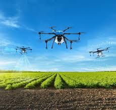
Agricultural specialists monitoring crop health and estimating yield levels
-
Emergency response units conducting search operations or assessing natural disaster zones
-
Urban planners studying land use, construction progress, or transportation patterns
Drones help solve problems related to accessibility, accuracy, time efficiency, and safety. They provide remote visibility in locations where humans cannot easily go, reducing risks while improving data quality. The rise of high-resolution imaging, cloud-based analysis tools, and automated flight programming has made drone-based insights more reliable than ever.
Recent Updates
Drone technology continues to evolve quickly, and the past year has brought several notable advancements.
AI-assisted Navigation (2024–2025):
Recent updates highlight the integration of onboard AI that allows drones to detect objects, avoid obstacles, and follow complex paths with minimal manual control. This has improved accuracy for mapping, inspection, and scientific monitoring tasks.
Enhanced Flight Time and Battery Innovation (2024):
New battery materials and power systems have extended flight duration, enabling longer missions and reducing the need for frequent returns. Improvements include better thermal management and more efficient energy distribution.
Growth in 3D Mapping and Digital Twin Applications (2024–2025):
Sectors like construction, mining, and urban development have increased the use of drone-generated 3D models. These models help track project progress, analyze ground conditions, and simulate future layouts.
Advanced Imaging Sensors:
Recent models (released in early 2024) have added multispectral and thermal imaging, expanding use cases in agriculture, public safety, and environmental analysis. These sensors allow users to observe changes in crop health, heat signatures, or land conditions.
Global Conversation on Airspace Integration (2024–2025):
Discussions on integrating drones into shared airspace have increased worldwide. Governments are exploring digital traffic systems that help drones coexist safely with manned aircraft.
Laws or Policies
Drone regulations vary by country, but most follow principles that promote safety, accountability, and controlled airspace usage. Below are typical regulatory themes found in many regions:
Registration Requirements:
Most countries require drone owners to register their UAVs if they cross a certain weight threshold. Registration links the drone to an operator for accountability.
Remote Identification:
Some regions have adopted remote ID rules that allow authorities to see a drone’s identification and location during flight. This ensures safer airspace monitoring.
Operational Limits:
Common rules include:
-
Keeping drones within visual line of sight
-
Staying below a specified altitude
-
Maintaining distance from airports, restricted zones, and crowded areas
-
Adhering to daylight or weather-based guidelines
Training and Knowledge Tests:
Operators may need to pass basic knowledge exams covering safety, navigation, and responsible flying. This encourages safe operations in both urban and rural environments.
Data Protection Rules:
When drones capture images or location information, privacy laws may apply. Operators must ensure responsible data handling and avoid capturing sensitive or private environments without permission.
Sector-Specific Permissions:
Some industries such as agriculture, research, mining, and public safety may require additional approvals for advanced operations, night flights, or automated missions.
Tools and Resources
Several helpful tools and platforms support drone operations, data processing, and navigation, especially for high-precision work.
Flight Planning Apps
-
Tools for setting flight routes, checking weather, and monitoring airspace conditions
-
Support for automated flight paths and mission scheduling
Mapping and Analysis Platforms
-
Cloud platforms that process drone imagery into maps, 3D models, or vegetation insights
-
Useful for environmental research, urban planning, and field monitoring
Navigation & Safety Tools
-
Airspace map apps displaying restricted zones
-
Altitude monitoring and wind forecast tools
Data Visualization Dashboards
-
Systems that convert raw drone data into charts, heat maps, or comparison graphs
-
Helpful for condition tracking, performance analysis, and environmental reporting
Hardware Accessories
-
Stabilization gear
-
Protective storage cases
-
Extended battery modules
Training Resources
-
Online educational content explaining drone basics, flight rules, and navigation principles
-
Sensor learning materials, including thermal, optical, and multispectral imaging guides
Template Libraries
-
Checklists for flight preparation
-
Incident reporting templates
-
Maintenance logs and inspection records
Below is an example of how drone-related information is often organized for quick reference:
| Category | Use Case | Typical Output |
|---|---|---|
| Mapping Tools | Land study, area measurement | 2D maps, contour lines |
| AI-powered Analysis | Agriculture, inspection | Health patterns, heat signatures |
| Navigation Tools | Route planning | Safe flight paths |
| Data Dashboards | Reports, presentations | Charts, graphs, summaries |
FAQs
What is a drone machine used for?
Drone machines are used for imaging, observation, mapping, inspection, environmental study, and data collection. Their aerial capabilities allow them to reach locations that are difficult or unsafe for humans.
How do drones navigate in complex areas?
Many drones use GPS, motion sensors, AI-based obstacle detection, and automated flight programming. These features help maintain stability and avoid collisions during flight.
Can drones fly in all weather conditions?
Most drones are designed for mild weather. Strong winds, rain, fog, or extreme temperatures can affect stability and sensor performance. Operators typically check weather guidelines before flights.
What types of sensors do modern drones use?
Common sensors include high-resolution cameras, thermal sensors, multispectral sensors, LiDAR units, and motion detectors. Each sensor supports specific technical tasks like vegetation analysis or structural inspection.
Do drone regulations change often?
Regulations may be updated as technology evolves. Governments periodically revise airspace rules, registration procedures, and safety guidelines to reflect new advancements and maintain public safety.
Conclusion
Drone machines have transformed how data is collected, analyzed, and shared across different fields. They support environmental research, infrastructure monitoring, urban development, and emergency operations with improved accuracy and real-time visibility. With advancements in AI navigation, sensor technology, and mapping tools, drones continue to expand their role in modern applications. Understanding their features, regulations, and available resources helps users operate them responsibly and make informed decisions as new technologies emerge.