Marine Navigation Equipment Explained: Complete Guide, Insights & Essential Knowledge
Marine navigation equipment refers to the instruments, technologies, and onboard systems that help vessels determine their position, direction, and movement while traveling across oceans, coastal waters, and inland waterways. These tools exist because safe and accurate navigation is essential for transporting goods, supporting fishing operations, managing scientific missions, and enabling global maritime trade.
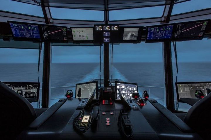
Modern navigation equipment has evolved from traditional compasses and paper charts to advanced digital systems powered by satellite networks and integrated sensors. Ships today rely on a combination of real-time data, automated monitoring, and situational awareness tools to travel efficiently while reducing navigational risks.
The field continues to grow as maritime operations expand and as technology offers new ways to track vessel movement, detect hazards, and manage voyages with improved reliability.
Importance
Marine navigation equipment matters because it directly influences safety, operational accuracy, and environmental protection. It affects professional seafarers, coast guards, marine researchers, recreational boaters, shipping companies, and crew responsible for monitoring routes and identifying hazards.
Reliable navigation tools help solve key challenges such as:
-
Preventing collisions and groundings through accurate position monitoring.
-
Supporting long-distance travel by providing dependable guidance across open sea routes.
-
Enhancing maritime situational awareness with radar, AIS tracking, and digital charts.
-
Protecting sensitive ecosystems by guiding vessels around restricted zones.
-
Enabling emergency response with real-time distress communication technologies.
Without advanced navigation systems, vessels would face greater uncertainty, slower travel, and higher risk during adverse weather or low-visibility conditions. For global maritime operations, these systems form the backbone of safe and coordinated movement.
Recent Updates
The past year has seen several notable updates across marine navigation technologies, reflecting ongoing modernization, safety priorities, and digital transformation.
2024–2025 trends and developments:
-
Digital Navigation Standardization (2024): Many maritime organizations increased adoption of standardized electronic chart display systems to reduce variation between vessels and improve consistency during training and operations.
-
GNSS Resilience Improvements (mid-2024): Efforts intensified to strengthen satellite navigation reliability due to concerns about signal interference. Redundant systems such as eLoran gained renewed attention.
-
AIS Data Expansion (late 2024): Additional satellite-based AIS receivers became operational, allowing broader global vessel tracking coverage, especially in remote ocean regions.
-
Integration of AI-assisted navigation (2025): Research accelerated on machine-learning algorithms capable of enhancing collision-avoidance decision-making by analyzing radar data, weather forecasts, and surrounding vessel movements.
-
Cybersecurity Updates (2025): As marine navigation systems increasingly rely on digital components, new guidelines emphasized secure configuration, monitoring of onboard network activity, and risk assessments for integrated bridge systems.
These updates highlight a shift toward automation, smarter data integration, and stronger digital protection. They aim to reduce navigational uncertainty and support crews with more reliable operational information.
Laws or Policies
Marine navigation equipment is influenced by international regulations and national maritime frameworks designed to protect life at sea and ensure consistent standards.
Key regulatory influences include:
International Maritime Organization (IMO)
-
Sets global standards for maritime safety.
-
Oversees requirements for navigational equipment on SOLAS-class ships.
-
Promotes use of Electronic Chart Display and Information Systems (ECDIS).
SOLAS Convention (International Convention for the Safety of Life at Sea)
-
Requires vessels to carry specific navigation tools and maintain them in working condition.
-
Sets rules for radar, AIS, GNSS receivers, compasses, and other essential equipment.
COLREGs (International Regulations for Preventing Collisions at Sea)
-
Guides the operation of navigation lights, radar use, and safe maneuvering rules.
-
Ensures vessels understand right-of-way and follow recognized maritime traffic practices.
Regional and National Maritime Authorities
-
Enforce local navigation policies, mandatory equipment lists, and safety certification.
-
Regulate vessel reporting systems in coastal zones.
Environmental and Protected Zone Policies
-
Require vessels to use navigation systems to avoid sensitive marine areas.
-
Support compliance with emission control areas by monitoring route restrictions.
These policies ensure that navigation equipment supports safe operations, aligns with international standards, and protects marine environments.
Tools and Resources
Marine navigation equipment includes a wide range of instruments and digital systems. Below is an organized overview of commonly used tools and useful resources for learning, route planning, and operational monitoring.
Core Navigation Equipment
| Navigation Tool | Purpose | Key Insight |
|---|---|---|
| GPS/GNSS Receivers | Determine vessel position using satellite data | Central to modern marine navigation |
| Marine Radar | Detects obstacles, vessels, and landforms | Useful in low-visibility conditions |
| AIS (Automatic Identification System) | Shares vessel identity and location | Improves situational awareness |
| ECDIS (Electronic Chart Display and Information System) | Digital chart visualization and route planning | Reduces reliance on paper charts |
| Gyrocompass & Magnetic Compass | Provide heading information | Essential backup to digital tools |
| Echo Sounder | Measures depth below hull | Helps avoid underwater hazards |
| Autopilot Systems | Maintain set course automatically | Supports long-distance travel |
| VHF Marine Radio | Communication for safety and coordination | Required for emergencies |
Helpful Digital Resources
These tools support learning, voyage planning, and staying informed:
-
Online marine chart portals for reviewing global nautical chart data.
-
Weather and ocean forecasting platforms providing wave height, wind, and current predictions.
-
AIS tracking websites offering real-time vessel movement maps.
-
Navigation software applications for training in ECDIS and radar interpretation.
-
Satellite data viewers displaying sea conditions, temperature, and maritime activity patterns.
-
Tide prediction tools for coastal operations and harbor navigation.
These resources help navigators, students, and maritime learners understand real-world traffic patterns, environmental conditions, and evolving safety practices.
FAQs
What is the most essential marine navigation equipment on a modern vessel?
Modern vessels typically rely on integrated systems that combine GPS/GNSS, radar, AIS, and ECDIS. Each tool supports specific tasks, but together they provide continuous positional awareness, hazard detection, and route guidance.
Why is ECDIS important in maritime navigation?
Electronic chart systems improve accuracy, reduce manual chart updates, integrate real-time data, and support decision-making. Many regulated vessels are required to use ECDIS under international maritime standards.
How does AIS improve maritime safety?
AIS broadcasts vessel identity, position, speed, and direction. Other ships, coastal authorities, and satellites receive this data, reducing collision risks and helping track global maritime traffic.
Are traditional navigation tools still relevant?
Yes. Despite digital advancements, tools such as magnetic compasses and paper charts serve as essential backups. They remain critical during equipment failure, satellite disruption, or emergency conditions.
How frequently is navigation equipment updated on ships?
Updates depend on vessel type and regulatory requirements. Digital chart updates are often weekly, while equipment inspections occur during scheduled safety checks or annual surveys.
Conclusion
Marine navigation equipment plays a central role in ensuring accuracy, safety, and reliability across global maritime operations. From satellite-based systems and digital charts to radar and communication tools, each component contributes to better situational awareness and efficient route management.
Recent developments highlight growing integration of digital technologies, expanded satellite tracking, and stronger cybersecurity efforts. Regulations from international and national authorities provide a foundation for consistent practices, helping protect both crews and the environment.