Smart Farming: Explore Modern Agricultural Technologies and Future Trends
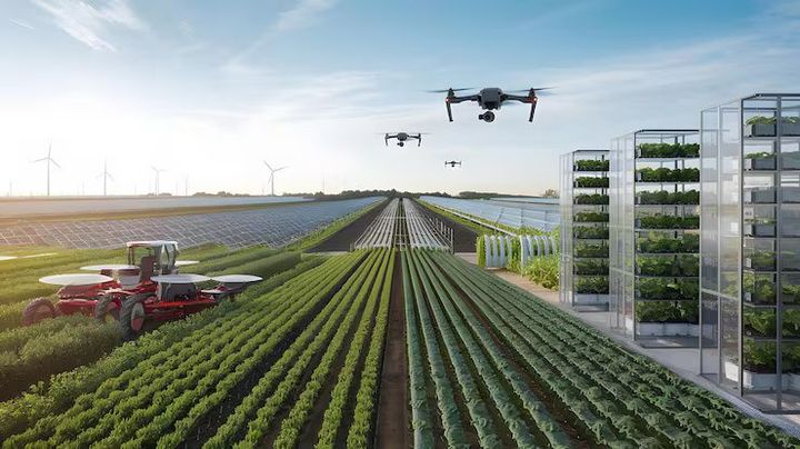
Smart farming combines agriculture with digital tools, sensors, satellite data, automation, and data analysis to support decisions about crops, soil, water, and farm operations. The idea developed from precision agriculture, where field measurements were used to understand differences within a farm rather than treating every area in exactly the same way. Today, smart farming can include connected weather stations, soil sensors, GPS-guided equipment, drones, remote sensing, artificial intelligence, and mobile applications.
Traditional farming depends heavily on field observation, local knowledge, seasonal patterns, and physical records. These remain important, but digital tools can add another layer of information. A soil sensor, for example, can measure moisture at selected points, while satellite imagery can show changes in crop growth across a larger area.
Smart farming does not mean that every farm needs advanced machinery. It is a broad approach in which technology is selected according to the crop, farm size, local conditions, and available infrastructure. A small farm may use a weather application and soil records, while a larger operation may combine GPS machinery, automated irrigation, remote sensing, and data dashboards.
Core technologies in smart farming
Several technologies form the foundation of modern agricultural systems. Internet-connected sensors collect field data, GPS helps locate machinery and map fields, and satellite imagery provides repeated views of vegetation and land conditions. Drones can capture detailed images from lower altitudes, while artificial intelligence can help identify patterns in large datasets.
Automation is another important area. Automated irrigation controllers can respond to soil moisture or weather information, while equipment guidance systems can help maintain consistent movement across fields. These technologies work together through software that organizes measurements into information that farmers can interpret.
| Technology | Common agricultural use | Main information or function |
|---|---|---|
| Soil sensors | Field monitoring | Moisture, temperature, selected soil conditions |
| GPS and mapping | Field operations | Location, routes, field boundaries |
| Satellite imagery | Crop observation | Vegetation and land-condition patterns |
| Drones | Local crop inspection | Detailed aerial images |
| Weather stations | Planning field activities | Temperature, rainfall, humidity, wind |
| AI and analytics | Decision support | Pattern detection and data interpretation |
| Automated irrigation | Water management | Timed or sensor-based irrigation |
Importance
Why smart farming matters
Agriculture faces several practical challenges, including changing weather, water limitations, soil degradation, crop diseases, labor constraints, and the need to manage inputs carefully. Smart farming can help organize information around these issues so that decisions are based on more than visual inspection alone.
Water management is one clear example. Instead of applying the same amount of water across an entire field, growers can use soil moisture readings, weather information, crop stage, and irrigation records to understand where and when water may be needed. Technology does not remove uncertainty, but it can make field observations more detailed.
Who is affected
The impact extends beyond farmers. Consumers depend on stable agricultural production, while food processors, transport networks, researchers, agricultural educators, and public agencies depend on reliable information about crops and conditions.
Smart farming also changes the type of knowledge needed in agriculture. Digital record keeping, sensor interpretation, equipment operation, mapping, and basic data analysis are becoming more relevant alongside traditional farming knowledge. Access to connectivity, training, electricity, and suitable devices remains an important consideration.
Challenges to consider
Technology can introduce its own difficulties. Sensors require correct installation and maintenance, connected equipment depends on reliable power or network access, and inaccurate data can lead to poor decisions. Data privacy and ownership also matter when information about land, crops, and farm activities is stored digitally.
Affordability is another practical issue, but it should not be viewed only through the price of equipment. Farmers also need to consider maintenance, connectivity, training, compatibility, and whether the information produced is useful for their particular crops and conditions.
Recent Updates
Digital agriculture in India
India has been expanding its digital agriculture infrastructure. The Digital Agriculture Mission was approved with an outlay of ₹2,817 crore and includes AgriStack, the Krishi Decision Support System, soil profile mapping, and digital crop estimation initiatives. The program is intended to create a more connected information framework for agriculture.
AgriStack uses a Farmer Registry, Geo-Referenced Village Maps, and a Crop Sown Registry. Government updates have described plans to create Farmer IDs at national scale and expand digital crop surveys across states and union territories.
AI, remote sensing, and field data
Recent developments also show greater use of artificial intelligence, machine learning, satellite information, and digital crop surveys. Government information from 2026 notes the use of AI and machine learning as one approach for technology-based yield estimation under the YES-TECH initiative for selected crops.
Another trend is the combination of different data sources. Weather observations, satellite images, soil information, crop records, and field surveys can be brought together to support decisions. This approach is gradually shifting agriculture from isolated measurements toward connected data systems.
More practical automation
Automation is also becoming more focused on specific tasks rather than complete farm replacement. Examples include automated irrigation, GPS-assisted machinery, drone-based field observation, greenhouse climate controls, and camera-based crop monitoring. The direction of development is generally toward tools that help people monitor larger areas and respond to changing conditions with more information.
Laws or Policies
Digital Agriculture Mission
India’s Digital Agriculture Mission provides a major policy framework for digital farming. Its structure includes digital public infrastructure for agriculture, including AgriStack, the Krishi Decision Support System, and soil profile mapping. The mission also supports digital crop surveys and crop estimation initiatives.
AgriStack is designed as a federated system involving state governments and union territories. Government material states that the system is built with privacy considerations aligned with the Digital Personal Data Protection Act, 2023.
Drone and data considerations
Agricultural drone use is also shaped by India’s aviation framework. Operators need to follow applicable civil aviation requirements, including rules concerning drone registration, operation, airspace, and safety. Requirements can vary according to the drone category and activity, so current official aviation guidance should be checked before an agricultural drone is operated.
Data-based agriculture also raises questions about consent, access, security, and responsible data handling. These issues become more important as farm records, land information, crop observations, and digital identities become connected across platforms.
Tools and Resources
Digital field tools
Farmers and agricultural learners can use several categories of digital resources. Weather applications can provide forecasts and rainfall information, soil testing records can help track field conditions, and satellite maps can provide broader views of vegetation and land changes.
Common tools include:
- Soil moisture sensors for monitoring water conditions at selected field points.
- GPS mapping tools for recording field boundaries and movement.
- Weather stations for local temperature, humidity, rainfall, and wind readings.
- Drone imaging systems for detailed field inspection.
- Farm record templates for tracking sowing, irrigation, inputs, observations, and harvest information.
- Satellite imagery platforms for reviewing crop and land patterns.
- Data dashboards for organizing sensor readings and field records.
Government agricultural portals can also provide information about crop guidance, weather, schemes, market information, and digital agriculture initiatives. The e-NAM platform is another part of India’s agricultural digital ecosystem, connecting participating agricultural markets through an electronic trading framework. Government reporting noted that 1,410 mandis across 23 states and four union territories had been integrated with e-NAM by the end of 2024.
Choosing suitable technology
A useful evaluation starts with the agricultural problem rather than the device itself. Farmers can consider what information is missing, how often it is needed, whether local connectivity is adequate, and whether the resulting data can be understood and acted upon.
Interoperability is also important. Tools that can exchange data through common formats or compatible systems may reduce duplicate record keeping. Training and technical support should also be considered because a sophisticated system is only useful when users can operate it correctly.
FAQs
What is smart farming?
Smart farming is an approach that uses digital technologies, sensors, connected equipment, mapping, automation, and data analysis to support agricultural decisions. It can be used for crop monitoring, irrigation, soil observation, field mapping, and other farm activities.
How does smart farming improve agriculture?
Smart farming can provide more detailed information about field conditions. For example, sensor readings and weather data can help farmers understand moisture patterns, while satellite or drone images can help identify areas that need closer inspection.
What technologies are used in smart farming?
Common technologies include GPS, soil sensors, weather stations, satellite imagery, drones, automated irrigation, artificial intelligence, machine learning, and farm management software. The combination used depends on the farm and crop.
Is smart farming suitable for small farms?
Smart farming can be adapted to different farm sizes. A small farm may use basic weather information, digital records, soil testing, or a few sensors rather than a large connected system.
What is the future of smart farming in India?
The future direction includes wider digital crop surveys, connected agricultural databases, remote sensing, AI-based analysis, automation, and more integration between farm data and public agricultural infrastructure. India’s Digital Agriculture Mission is a major part of this transition.
Conclusion
Smart farming brings digital information, sensing, automation, and data analysis into agricultural decision-making. Its development is linked to the growing need to manage water, soil, crops, weather risks, and field operations with more detailed information. In India, recent policy developments such as the Digital Agriculture Mission are expanding the digital foundation for agriculture. The future of farming is likely to involve a combination of traditional knowledge and connected technologies, with privacy, training, data quality, and practical usability remaining important considerations.